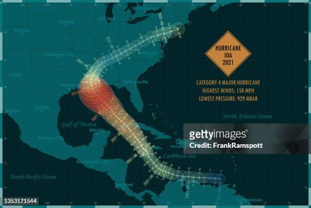
Meteorologist Jessica Schauer works on tracking Hurricane Earl at the National Hurricane Center on August 30, 2010 in Miami, Florida. Jessica said...
Florida Governor Charlie Crist stands in front of a hurricane tracking map during a visit to the National Oceanic and Atmospheric Administration...
In this graphic released by NASA September 22 a sea surface height map of the Gulf of Mexico, based on altimeter data from four satellites including...
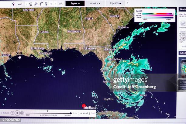
Meteorologist Dennis Feltgen places the tropical storm symbol on Tropical Storm Nate on a tracking map at the National Weather Service's National...
Meteorologist Jessica Schauer works on tracking Hurricane Earl at the National Hurricane Center on August 30, 2010 in Miami, Florida. Jessica said...
Hurricane tracking map is seen inside Donald Francis' home which was destroyed by Hurricane Gustav September 2, 2008 in Houma, Louisiana. Gustav...
Symbols representing storm activity are seen on a tracking map at the National Weather Service's National Hurricane Center at Florida International...
Symbols representing storm activity are seen on a tracking map at the National Weather Service's National Hurricane Center at Florida International...
Symbols representing storm activity are seen on a tracking map at the National Weather Service's National Hurricane Center at Florida International...
Meteorologist Dennis Feltgen places the wind speed of Nate on a tracking map at the National Weather Service's National Hurricane Center at Florida...
Michael Brennan, Chief Hurricane Specialist Unit, walks past the hurricane tracking map at the NOAA NWS National Hurricane Center as the media is...
Meteorologist Jessica Schauer works on tracking Hurricane Earl at the National Hurricane Center on August 30, 2010 in Miami, Florida. Jessica said...
Meteorologist Jessica Schauer works on tracking Hurricane Earl at the National Hurricane Center on August 30, 2010 in Miami, Florida. Jessica said...