The Port of New York and how it was formed - 3 of 8 - stock video
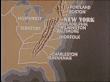
Map diagraming US hinterland access to Atlantic ports.


PURCHASE A LICENCE
Get personalised pricing by telling us when, where, and how you want to use this asset.
Not sure if you can use this video for commercial purposes? Find out
DETAILS
Credit:
Creative #:
641760540
Licence type:
Rights-ready
Collection:
Archive Films: Creative
Max file size:
720 x 486 px - 551 MB
Clip length:
00:01:56:10
Upload date:
Location:
New York City, New York, United States
Intended for:
Editorial use
Release info:
Not released
Mastered to:
QuickTime 8-bit Photo-JPEG SD 720x576 25p
Categories:
- 1 Minute or Greater,
- 1940-1949,
- 1949,
- Accessibility,
- Archival,
- Atlantic Ocean,
- Business Finance and Industry,
- Cartography,
- Colour Image,
- Day,
- Diagram,
- Film - Moving Image,
- Film Montage,
- Freight Transportation,
- Harbour,
- Horizontal,
- Industry,
- Map,
- Medium Shot,
- New York City,
- No People,
- Organisation,
- Outdoors,
- Real Time - Footage,
- Shipping,
- Transportation,
- USA,
- Video with Sound,
- Western Script,