Rand...
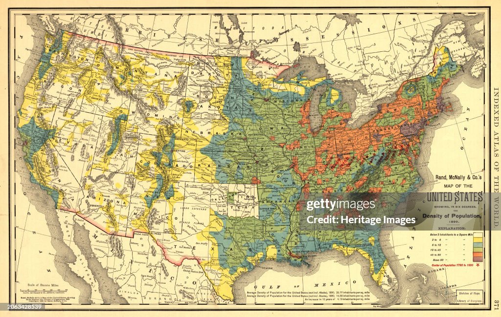
Rand, McNally & Co.'s map of the United States showing, in six degrees the density of population, 1890, (1892). This map, published in 1892 by the Chicago-based Rand McNally and Company, shows the population density of the United States in 1890. Six shades of color are used to indicate the different levels of population density by location, ranging from fewer than two inhabitants per square mile (2.59 square kilometers) to more than 90 inhabitants per square mile. The most densely populated parts of the country are in the Northeast and parts of the Midwest. The West is for the most part sparsely populated, although already by this time Denver, Los Angeles, Salt Lake City, San Francisco, and Seattle are emerging as major cities. Red stars are used to indicate the westward movement of the country's center of population, caused by a century of migration and settlement. A note at the bottom explains that in 1890 the overall population density of the United States (excluding Alaska) was 20.77 inhabitants per square mile, up from 16.58 inhabitants per square mile a decade earlier. Also shown are major geographic features including national and state borders, mountains, rivers and lakes, major roads, cities and towns, national parks, and Indian reservations. Creator: Rand McNally. (Photo by Heritage Art/Heritage Images via Getty Images)

PURCHASE A LICENCE
How can I use this image?
$475.00
+GST AUD
Getty ImagesRand..., News Photo Rand... Get premium, high resolution news photos at Getty ImagesProduct #:2063428539
 Rand... Get premium, high resolution news photos at Getty ImagesProduct #:2063428539
$650+GST$200+GST
Getty Images
In stockPlease note: images depicting historical events may contain themes, or have descriptions, that do not reflect current understanding. They are provided in a historical context. Learn more.
DETAILS
Restrictions:
Contact your local office for all commercial or promotional uses.
Credit:
Editorial #:
2063428539
Collection:
Hulton Archive
Date created:
01 January, 1900
Upload date:
Licence type:
Release info:
Not released. More information
Source:
Hulton Archive
Object name:
3004106
Max file size:
6144 x 3893 px (52.02 x 32.96 cm) - 300 dpi - 23 MB
- 1890,
- 1890-1899,
- 19th Century,
- 19th Century Style,
- Archival,
- California,
- City,
- City Life,
- City Of Los Angeles,
- Colorado,
- Colour Image,
- Colours,
- Country - Geographic Area,
- Country Map,
- Demography,
- Denver,
- History,
- Horizontal,
- Human Interest,
- Lake,
- Library,
- Map,
- Mountain,
- Mountain Range,
- National Park,
- Photography,
- Physical Geography,
- River,
- Road,
- Salt Lake City,
- San Francisco - California,
- Seattle,
- South African Currency,
- Text,
- Thoroughfare,
- Town,
- USA,
- Utah,
- Washington DC,